Hurricane-Ready: How States can Better Model Flooding Risk and Improve Mass Evacuations

Hurricane season is far from over, but with four major hurricanes – Category 3 or greater – already causing untold damage in Texas, Florida, and Puerto Rico, 2017 has already proved to be a brutal one.
The steady stream of unrelenting devastation has impacted millions of Americans who face the choice of rebuilding or moving elsewhere. The damages to the commercial real estate market in Houston is estimated at $55 billion while property damage in Florida could reach $65 billion. Meanwhile, in Puerto Rico, with its power infrastructure in ruins, the Army Corps reports that the U.S. territory looks a lot like Iraq in 2003.
The good news is that improvements in hurricane forecasting has prevented the deadly loss of human life that characterized these storms in the past. In 1900, poor forecasting and inadequate warning systems led to the death of up to 12,000 people in Galveston, Texas, making that year’s storm the deadliest natural disaster in U.S. history.
With Better Hurricane Forecasting Comes Another Challenge
While science is saving lives, the corollary is that more accurate forecasting is creating a headache for Departments of Transportation (DoTs) who plan roads and highways for everyday use, not extreme cases. As storms approach, people hit the roads. The knock-on effect of mass evacuations, like those seen in Florida as residents fled Hurricane Irma, are jammed highways.
One potential solution to such congestion is to introduce contraflow systems. Gov. Rick Scott got into hot water for failing to authorize contraflow lane reversal on the state’s major north-south highways, yet to do so would have made things worse for emergency services needing to move against the traffic flow.
So, what’s the quickest way to get people out of harm’s way? Alternative modes of transportation like trains and buses, are one option. But DoTs can also plan ahead for evacuations using data and technology.
DoTs have considerable amounts of data about traffic patterns and highway use. Speaking to Construction Dive, Sean Qian, assistant professor of civil and environmental engineering at Carnegie Mellon University said this data “could be useful in creating models that can inform officials’ plans for high-capacity events like a mass evacuation.”
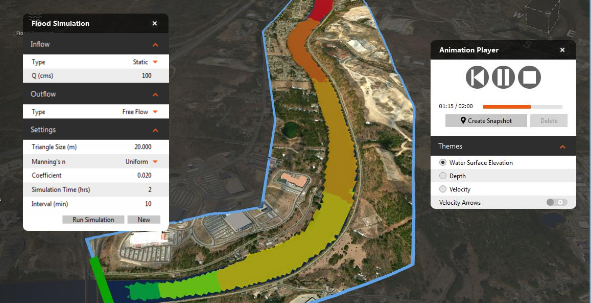
Flood simulation programs, like Autodesk InfraWorks 360, also play a role. InfraWorks lets civil engineers create models that predict where, how much, and how long water will flow into a certain area in the event of heavy rain events. In the same article, Autodesk’s Eric Chappell, had this to say:
“You model an event based on rainfall and topography…Once you know what you're up against, you can change numbers and run a different model very quickly."
You can see the same principle at work with this model of the Oroville dam spillway failure which Autodesk created after the incident to show more clearly what happened and where the water may have ended up, had the dam broken fully.
Read more about this topic in our earlier article: As the Waters Rise, Flood Simulation Tools Can Help.


