Satellite Imagery: An Essential Government Tool is Within Reach
Want a birds-eye view of your house? How about a high-resolution image of your construction site? You no longer have to be a spy to see this data: Satellite imagery has found a place in our everyday lives.
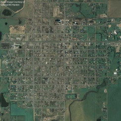
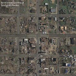
 But satellite imagery is more than just a curiosity. It’s easier than ever to use this technology for many applications from construction to natural disaster recovery. Many industries, including federal, state and local agencies, and natural resources, architecture, engineering and construction companies, use satellite imagery as an essential part of their jobs.
When the U.S. government launched the first satellite in 1958, the country was in the midst of the Cold War. In the 1990s, satellite imagery became commercially available, and an industry was born. Today, everyday users can obtain satellite data from commercial suppliers to help
  add depth of understanding to their projects.
So why would you use satellite imagery? First, it can help create a more accurate base map, which is a map on which primary data and interpretations can be plotted such as roads, rivers, and city boundaries, said Jeremy Hale, Vice President at Abeo Geospatial, a DLT Solutions and Autodesk® partner.
“Satellite data provides another level of detail that can serve numerous purposes, not just a few applications,” Hale said. With high-resolution satellite data, GIS and CAD users can acquire imagery related to a project area and within days have the new imagery ingested in their GIS or CAD system, he said. The satellite can provide a shot of the target area, for example, the site of a construction project, when needed.
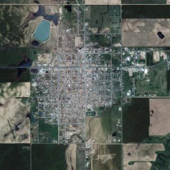
Another reason to use satellite imagery is for multi-spectral analysis. Multi-spectral imagery can capture light from frequencies beyond the visible light range, such as infrared. “This can allow extraction of additional information that the human eye fails to capture,” Hale said.
Multi-spectral imagery is useful in a variety of applications such as soil features, fire risk management, wetlands mapping and vegetation analysis and classification.
 Even organizations that spend money every year on aerial photography can take advantage of satellite imagery by deploying a leap- frog strategy, Hale said. “Use satellite imagery every other year to supplement your aerial photography,” he said.
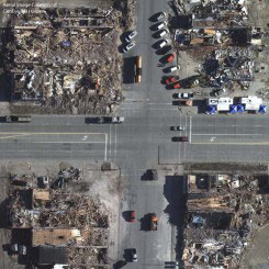
Satellite imagery can provide the high resolution that managers need to do their jobs, Hale said. The new GeoEye-1 satellite lets users see features as detailed as vehicle windshields and road striping, and the satellite imagery is GIS ready. GeoEye, Inc. is a DLT partner. GeoEye offers the highest resolution satellite imagery commercially available, and it is in color, Hale said.
So where does Autodesk come in? The company offers products that can easily ingest satellite imagery, such as AutoCAD® Map 3D and AutoCAD® Raster. “If a client needs imagery for a project they can get it in a matter of days – and it’s GIS/CAD- ready,” Hale said. “It’s all about accessibility and how quickly we can use this data.”
Satellite or Aerial?
Many firms use aerial photography for projects that require high-resolution aerial data, but they should consider satellite imagery as a more practical alternative, said Hale. Satellite imagery provides huge benefits to GIS updates, economic development, environmental protection and preservation, and
  disaster management and public safety, he said.
And because satellite imagery is collected digitally, there is no data loss during the scanning process. Digital imagery contains more information and covers a significantly larger ground area than aerial photography. Satellites are more flexible in inclement weather conditions because they can revisit target sites every few days until they get the shot. Also, satellites aren’t limited by national and international airspace management issues.
Still not ready to give up aerial photography? Satellite imagery can supplement aerial programs. By using high-resolution satellite data, organizations can keep costs down by using aerial photography one year and satellite imagery the next in a leap-frog strategy.
Colleen O’Hara, Reporter, [acronym]
Originially published in [acronym] magazine, Issue 11
 But satellite imagery is more than just a curiosity. It’s easier than ever to use this technology for many applications from construction to natural disaster recovery. Many industries, including federal, state and local agencies, and natural resources, architecture, engineering and construction companies, use satellite imagery as an essential part of their jobs.
When the U.S. government launched the first satellite in 1958, the country was in the midst of the Cold War. In the 1990s, satellite imagery became commercially available, and an industry was born. Today, everyday users can obtain satellite data from commercial suppliers to help
  add depth of understanding to their projects.
So why would you use satellite imagery? First, it can help create a more accurate base map, which is a map on which primary data and interpretations can be plotted such as roads, rivers, and city boundaries, said Jeremy Hale, Vice President at Abeo Geospatial, a DLT Solutions and Autodesk® partner.
“Satellite data provides another level of detail that can serve numerous purposes, not just a few applications,” Hale said. With high-resolution satellite data, GIS and CAD users can acquire imagery related to a project area and within days have the new imagery ingested in their GIS or CAD system, he said. The satellite can provide a shot of the target area, for example, the site of a construction project, when needed.
Another reason to use satellite imagery is for multi-spectral analysis. Multi-spectral imagery can capture light from frequencies beyond the visible light range, such as infrared. “This can allow extraction of additional information that the human eye fails to capture,” Hale said.
Multi-spectral imagery is useful in a variety of applications such as soil features, fire risk management, wetlands mapping and vegetation analysis and classification.
 Already many government and non-government industries use satellite imagery in their daily work. Federal agencies use it to help manage industries that impact transportation, infrastructure, urban development, environment and homeland security. During Hurricane Katrina, FEMA used satellite imagery to help coordinate its rescue efforts. The agency compared images taken before the disaster to images taken after the disaster to help determine where such features as roads and homes used to be located.
 Even organizations that spend money every year on aerial photography can take advantage of satellite imagery by deploying a leap- frog strategy, Hale said. “Use satellite imagery every other year to supplement your aerial photography,” he said.
Satellite imagery can provide the high resolution that managers need to do their jobs, Hale said. The new GeoEye-1 satellite lets users see features as detailed as vehicle windshields and road striping, and the satellite imagery is GIS ready. GeoEye, Inc. is a DLT partner. GeoEye offers the highest resolution satellite imagery commercially available, and it is in color, Hale said.
So where does Autodesk come in? The company offers products that can easily ingest satellite imagery, such as AutoCAD® Map 3D and AutoCAD® Raster. “If a client needs imagery for a project they can get it in a matter of days – and it’s GIS/CAD- ready,” Hale said. “It’s all about accessibility and how quickly we can use this data.”
Satellite or Aerial?
Many firms use aerial photography for projects that require high-resolution aerial data, but they should consider satellite imagery as a more practical alternative, said Hale. Satellite imagery provides huge benefits to GIS updates, economic development, environmental protection and preservation, and
  disaster management and public safety, he said.
And because satellite imagery is collected digitally, there is no data loss during the scanning process. Digital imagery contains more information and covers a significantly larger ground area than aerial photography. Satellites are more flexible in inclement weather conditions because they can revisit target sites every few days until they get the shot. Also, satellites aren’t limited by national and international airspace management issues.
Still not ready to give up aerial photography? Satellite imagery can supplement aerial programs. By using high-resolution satellite data, organizations can keep costs down by using aerial photography one year and satellite imagery the next in a leap-frog strategy.
Colleen O’Hara, Reporter, [acronym]
Originially published in [acronym] magazine, Issue 11


